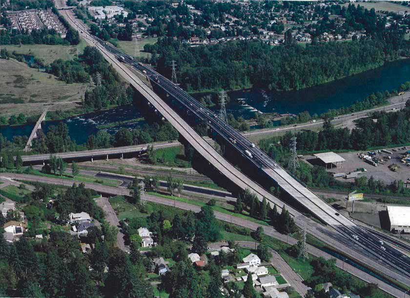
Troubled Bridges Over Water
I-5 Willamette River Bridge:
widening the interstate as we pass Peak Oil
on this page:
- ODOT's Revised Environmental Assessment admits the goal is six lanes
- ODOT responses to comments regarding Peak Oil and Peak Traffic
- Comments on the I-5 Willamette River Bridge Environmental Assessment, February 19, 2008
ODOT's Revised Environmental Assessment, November 2008
The new bridges will be built with enough width to eventually carry up to six lanes of traffic to meet the 20-year design for future traffic needs.
p. 1The traffic capacity of I-5 would not change as a result of the proposed bridge replacement. No additional lanes, channelization changes, or speed zone changes are planned.
p. 4The TransPlan (2002) includes two I-5 projects (No. 260 and150) in the list of Future (Beyond 20-Years) Capital Investment Actions (Chapter 3: Table 1b-Future (Beyond 20- Years) Capital Investment Actions: Roadway Projects, Page 31) described as:
No. 260 I-5 from 1-105 to Highway 58 (Goshen): Widen remaining sections to 6 lanes.
No. 150 I-5 at Willamette River/Franklin Boulevard Interchange:
Interchange reconstruction to create one full interchange to improve operations and safety, reconstruct ramps and bridges to modern standards, and provide for 6 lanes on I-5.The I-5 Willamette River Bridge Project is included in TransPlan’s list of authorized transportation improvements by way of these two projects; therefore, an amendment to the TransPlan would not be required. p. 32
ODOT responses to comments regarding Peak Oil and Peak Traffic
Provided in response to official testimony provided to the 2008 Environmental Assessment -- the numbered paragraphs are comments from Mark Robinowitz, the indented paragraphs are ODOT's reply as presented in the November 2008 Revised Environmental Assessment. The bold sections are added for emphasis.
1 I strongly support the No Build Alternative to ensure the existing detour bridge can remain in use for decades (i.e., through the rest of the oil era).
Noted.
2 When it was determined that the original I-5 bridge was cracked and deteriorating at dangerous levels, the original proposal to do a seismic safety upgrade to the bridge was abandoned. It is astounding that ODOT and FHWA did not decide to replace the bridge only one time, instead of twice. While several staff from these agencies have patiently explained the various regulations that they thought forced them to make this choice, as energy costs increase and energy availability decreases, wasting nonrenewable resources on the rebuilding of the same bridges over and over will become more difficult. The highway construction lobby will still make money fixing broken bridges.... While some will think this is outside the scope of this EA and therefore moot, it points to the need for a policy review of the way Oregon's bridge replacement program is being run -- without any consideration of the arrival of Peak Oil.
The detour was constructed as a temporary bridge due to the need to maintain traffic flow on I-5 and to do it on an expedited basis. Keeping the old bridge in service while a permanent replacement was designed and constructed would have required placing weight restrictions on the bridge. Such restrictions would have resulted in a 200 mile detour for heavy haul trucks, which would result in considerable disruption to and wear on alternative routes. This, in turn, would have considerable short- and long-term costs associated with longer travel distances, delays, and maintenance and repair requirements. Moreover, the detour bridge was constructed with the most cost effective design, which did not meet the bridge and highway design standards for a permanent bridge. For example, it does not have standard shoulders or meet seismic standards for a permanent facility.
3 The main point of these comments is that “Peak Traffic” caused by Peak Oil means that there is no need to widen I-5 through the study area (future traffic increases are not likely given increasing fuel prices and decreasing fuel availability). Widening this section of Interstate 5 risks violating Federal Highway Administration policies and regulations about “independent utility” that address segmentation of large projects. (Later on Page 5) ... Traffic projections for the design year of this project and all other highway projects need to factor in reasonable estimates of oil decline that will impact traffic levels two decades in the future. [Note: the commenter provided several reports and articles on the subject of peak oil.]
Peak oil refers to the point in time at which the maximum global petroleum production rate is reached, after which the rate of production enters a terminal decline. The comment is correct that peak oil was not factored into the estimates of future traffic demand. Future traffic projections were based on standard methods used by ODOT and approved by FHWA, and incorporating land use projections developed by the Lane Council of Governments (TPAU, 2006). The I-5 Willamette River Bridge Project does not include improvements that change the capacity of I-5 to handle traffic.
Most estimates place peak global production occurring some time between 1990 and 2040. When oil production drops below oil demand, it is likely to cause petroleum prices to increase. There are uncertainties, however, regarding peak oil’s timing and the availability of substitute fuels. Peak oil's effect on transportation fuel prices and travel behavior will depend largely on when peak oil occurs and the availability of substitute fuels. However, even substantial fuel cost increases may not significantly change driving habits. The American Automobile Association reported in their July 30, 2008 Fuel Gauge Report that the national average price for regular unleaded gasoline was $3.93/gallon compared to $2.88/gallon one year earlier: an increase of over 36%. The FHWA’s monthly Traffic Volume Trends report for May 2008 states that there was a 3.2% reduction in miles traveled on US Highways between May 2007 and May 2008 as a result of higher gas prices. Because fuel costs represent only a portion of total transportation costs (which include everything from car payments, to insurance and maintenance) even large growth in fuel costs translates to a smaller growth rate in total transportation cost, which is what most directly affects travel demand in the long term.
Given that the design life for the bridge is 100 years or more, the potential for I-5 to be widened in the future north and/or south of the bridge led the Federal Highway Administration to direct that the design of the replacement bridge be of sufficient width to accommodate future widening without reconstruction, even though widening of I-5 is not currently planned. In addition, the wider bridge section could be used for alternative transportation modes such as transit if it is not needed for roadway capacity.
Regarding whether the project lacks “independent utility,” the project involves replacement of an existing bridge and does not change the capacity of I-5. 23 CFR 771.111(f) states: “In order to ensure meaningful evaluation of alternatives and to avoid commitments to transportation improvements before they are fully evaluated, the action evaluated in each EIS or finding of no significant impact (FONSI) shall...have independent utility or independent significance, i.e., be usable and be a reasonable expenditure even if no additional transportation improvements in the area are made....” The FHWA has affirmed that the proposed dimensions of the replacement bridges represent an appropriate design for the project (Taylor, 2007).
4 The No Build/Low Build alternative is the most cost effective and least energy consumptive means of meeting the purpose and need of having a bridge across the river likely to withstand seismic shaking.
The No Build Alternative would require less short term energy expenditures than the Build Alternative. However, the No Build Alternative does not meet the purpose and need of the project.
5 Traffic projections for the year 2031 (the design year for the project) are unrealistic since by then the world will be on the downslope of Hubbert's curve. The National Environmental Policy Act…states that environmental documents need to factor in “new circumstances” that are relevant. The fact that we have reached Peak Oil (for conventional oil) and climate change is happening faster than climatological models predicted suggests these physical limits need to be factored into this and all other transportation studies.
There is substantial uncertainty regarding the timing of peak oil, the future availability of substitute fuels and technology, and the effects of peak oil on transportation. Numerous factors will influence the timing and impact of peak oil at the global and local scale. These factors include national and international energy policies, international relations, fuel and transportation taxes and fees, alternative fuel and technology research and development, fuel efficiency, agricultural policy and practices, and local land use regulations. How these factors and others will combine with peak oil to affect travel demand is unknown and subject to broad speculation. FHWA and ODOT have agreed that the appropriate place to address comments on peak oil is in these responses to comments. Global climate change is addressed in the response to Document 4, Comment 1.
6 The EA needs to study how merely replacing the damaged bridge with a new bridge that is designed for four lanes (plus an emergency shoulder) would allow more resources to be used to repair or replace other damaged bridges.
As noted in the response to Comment 3, the FHWA has provided direction on the number of lanes for the bridge. This was a primary criterion in project development. State funding from the OTIA III program and federal funding have been identified for the project, as documented in Section 1.1 of the EA. This funding is provided to develop and deliver a project that meets the purpose and need. How funding is apportioned for the statewide bridge program is detrermined by the Oregon Legislature, ODOT, and the Oregon Transportation Commission not within the scope of the NEPA analysis for the project.
7 [T]his stretch of I-5 would be widened under the Build option, part of a larger effort throughout Lane County, which would have substantial financial impacts and possibly displace several businesses. These impacts need to be included in the analysis of cumulative impact of building a six lane bridge.
Under the Build Alternative, only the bridges and the approaches to the bridges would be widened. Even though the bridges would be physically wider than the existing bridges, they would be striped for two lanes in each direction, to match the existing lanes of I-5. No additional lanes on I-5 are included in this project. Widening of I-5 north or south of the bridge is not a programmed or funded improvement in the 20 –year Region Transportation Plan and, therefore, ODOT and FHWA did not identify it as a “reasonably foreseeable future action” and therefore it was not included in the cumulative effects analysis for the project. It should be noted that any potential future project to widen I-5 would be far greater in scope than the I-5 Willamette River Bridge replacement project and would require a substantial environmental review under NEPA.
8 [Spread of invasive plants] would be a greater problem for the Build alternative than the No Build alternative, since there would be far greater construction activities if a six lane bridge were built over a four year period.
This is correct. The REA text will indicate that the larger project with longer duration would have a greater likelihood to introduce or spread invasive plants.
9 [I]t is obvious that the County and ODOT are quietly piecemealing plans for widening of the interstate and a cumulative EIS analysis is needed for the entire project. If ODOT’s position is there are no plans to widen I-5, then there is no need to plan a six lane bridge that would cost considerably more than merely replacing the existing bridge….
See response to Comment 7 above regarding future widening of I-5.
10 The U.S. could immediately reduce oil consumption by an estimated 4% by rolling back highway speed limits to 55 mph.
Noted. It is not within the scope of the I-5 Willamette Bridge Project to change the speed limit on I-5.
11 Widening I-5 to facilitate an increase in traffic is intended to facilitate more travel and therefore would contribute to an increase in combustion of fossil fuels.
The project does not involve widening of I-5. The bridge will be striped for two lanes in each direction. If widening of I-5 is considered in the future, it would be subject to environmental review under NEPA. At that time, an evaluation of fuel consumption and energy use consistent with adding capacity to the transportation system would be conducted. See response to Comment 7 above regarding future widening of I-5.
12 The EA needs to include the cumulative impact of using cement and concrete that was made with incinerated hazardous wastes.
The OTIA III Materials and Contamination Performance Standards contain specific standards for material procurement and use. The standard for concrete allows the use of concrete that contains fly-ash (which is generally from coal-fired electric generation) in accordance with ODOT specifications. The contractor will not use any material for this project that is not in accordance with ODOT specifications. ODOT’s policies include the removal or remediation of hazardous waste from existing conditions and do not allow for the use of known hazardous materials that would endanger the public..
13 The EA also needs to include the full impact of mining ores and gravels to produce the raw material for the new, larger bridge, as well as the environmental and toxic impacts of the paints, bolts, girders, wire, lighting systems, and all other components of the new, larger bridge.
Selection and procurement of the materials for construction would be the responsibility of the construction contractor. The type of materials (such as steel vs. concrete) to be used in the bridge construction will not be selected as part of the NEPA process. These will be determined as part of the design process. Materials will be procured in accordance with the Materials Procurement and Use Hierarchy from the OTIA III Materials and Contamination Performance Standard. The hierarchy specifies utilization of products and materials in a manner that prevents waste generation, promotes materials reuse and recycling, minimizes disposal, and promotes sustainability.
For the details of the Materials and Contamination Performance
Standards, see:
www.obdp.org/files/partner/environmental/MaterialsandContaminationManual.pdf
14 The “prudent and feasible” alternative is to select the No Build (Low Build) alternative.
Regarding Section 4(f), the proposed temporary occupancy of Alton Baker Park would constitute a de minimis use (consistent with 23 CFR 774.17) hence alternative analysis is not required. Further, the prudent and feasible test only applies to alternatives that meet the purpose and need of the project. The No Build alternative does not meet the purpose and need of the project. It should be noted that ODOT has been actively coordinating with the Eugene Parks and Open Space Division and Willamalane Park and Recreation District, as well as the Citizen Planning Committee for the Whilamut Natural Area, regarding measures to avoid, minimize and mitigate construction impacts associated with the project. This process will be memorialized in a formal agreement between the park administrators and ODOT. The mitigation measures were considered in making the de minimis determination. Further, Eugene Parks and Open Space Division has concurred with this determination.
15 Four years of proposed construction in the park is not a “de minimus” impact on the park.
See Comment 14 response above.
16 Putting heavy equipment, construction materials, gravel, etc. on natural soils results in compaction and other ecological damage that can take decades to reverse. The construction would cause essentially permanent damage to the park and would also have “constructive use” impacts on the park; therefore, minimizing the time of construction via the No Build alternative is mandatory. Even building a new four lane bridge (versus a six lane bridge) would reduce construction time over a six lane expansion.
A constructive use impact occurs when a project does not directly take land from a Section 4(f) resource, but the project's proximity impacts substantially impair activities, features, or attributes of the affected property. The temporary occupancy of a portion of the park during construction and proposed mitigation measures are documented in the EA. It should be noted that the project proposes to temporarily occupy approximately 2 acres of Alton Baker Park adjacent to the bridge for staging; the overall area of Alton Baker Park is 400 acres. ODOT is coordinating with Eugene Parks and Open Space Division regarding the location of temporary staging areas and measures to avoid and mitigate park impacts.
17 The EA needs to state whether LWCF funds were used or not.
ODOT and Oregon Parks and Recreation Department concluded that LWCF funds were used for the acquisition of Alton Baker Park. ODOT is proceeding with analysis of conversion in accordance with Section 6(f) of the Land and Water Conservation Fund Act. The REA will include this information and commitments regarding replacement property.
18 The scale of these bridges suggest the No Build (Low Build) Alternative needs to be adopted to free up funds to repair or replace other defective structures in the state highway system.
See Comment 6 response above.
19 Public input ignored…The comments that were submitted to ODOT to factor Peak Oil and climate change into traffic projections were completely ignored in the EA, even though some of the staff privately admitted these concerns have merit.
ODOT conducted public involvement activities, including two open house meetings during the development of the EA. All comments submitted through this process were carefully considered by the project team, ODOT and FHWA, even if they were not specifically addressed in the EA.
20 Sustainability really means zero use of fossil fuels and zero use of mined mineral ores.
Because this project is part of the OTIA III program and to maintain consistency with other projects in the program, the EA used the definition of “sustainability” adopted for the program.
21 If a new bridge is built next to the allegedly temporary bypass bridge, it should be the design that would be strongest to resist the Cascadia Subduction Zone earthquake and the potential dam failure on the Middle Fork and damns [sic] upstream from Cottage Grove (the latter were not designed with any seismic safety criteria, according to the City of Eugene)
The replacement bridges will be designed to the current design standards, including seismic standards.
22 It is unlikely that compacted soils would be quickly regenerated with their full range of microbial and mycological diversity. The EA needs to include scientific analysis of how diverting park land to construction for a period of years has allegedly resulted in full recovery of the original soils -- and if this information is unavailable, then the “use” of the park land for construction must be considered a permanent “use” of the 4(f) resource.
The construction contractor will be required to monitor and ensure the success of the revegetation and wetland restoration/creation for five years, consistent with the OTIA III Environmental Performance Standards. Also of note, the area of Alton Baker Park proposed for temporary occupancy for staging would be approximately 2 acres, representing a small area of Alton Baker Park, which is 400 acres.
23 I realize that “highway modernization” money cannot be diverted to upgrading the railroads of Oregon (and that there isn’t excess highway construction money that could be diverted anyway). Nevertheless, as Peak Oil becomes harder to deny, it would be nice for ODOT to upgrade the priority for railroad infrastructure while we still have at least some rail connections to other parts of North America.
Noted.
24 The “spaghetti bowl” of a potential I-5 interchange [at Franklin Boulevard] would have major riverfront impacts, would cause residential displacements and disruption to neighborhoods, would be very expensive, and would be less than one mile from the I-105 interchange (improper spacing according to ODOT design standards). The money for the interchange would be better spent on seismic upgrades to the dangerous dams upstream from Glenwood.
As noted in previous comment responses, the project does not involve changes to I-5/Franklin Boulevard access other than minor modifications of the existing ramps. Further, no permanent right-of-way acquisition would result from the I-5 Willamette River Bridge Project. The current temporary easement east of I-5 in the Whilamut Natural Area would be vacated and some of the fill that supports the detour would be removed. No residential or business displacements or relocations would result from the project. State or federal transportation monies cannot be spent of dam upgrades.
Comments on the I-5 Willamette River Bridge
Environmental Assessment
February 19, 2008
prepared by:
Mark Robinowitz
- No Build Alternative is a “Low Build” option
- Should have built it once, not twice
- Factor in Peak Oil to traffic modeling
- most cost effective alternative should be selected
- Peak Traffic and highway plans
- Indirect and Cumulative Effects of Six Lanes
- Why “replacements for oil” do not change Peak Traffic
- 55 mph needed
- Air Quality
- Toxic Cement
- Section 4(f) prohibits “use” of park land if there is a “prudent and feasible” alternative
- Public Input ignored
- Sustain A Bull
- different designs for a new, wider bridge:
- Trains need to be prioritized by ODOT
- Comments submitted to the EA Scoping Meetings
- I-5 / Franklin interchange proposal is not practical
- ODOT = Oregon Department of Bridge Repair
- Troubled Bridges Over Water: the I-5 bridge crisis
- Los Angeles: Bridges Remain Key Quake Risk
- I-5 Bridge project needs to look at dangerous dams
- The Willamette Valley Tsunami: Dam Collapses from Flood or Earthquake
- Eugene's Multi-Hazard Mitigation Plan
Most people do not enjoy having their entire worldview discredited; it sets them uncomfortably adrift. Scientists are no exception. A paradigm tends to be so greatly cherished that, as new knowledge or evidence turns up that contradicts it or calls it into question, the paradigm is embroidered with qualifications and exceptions, along with labored pseudo-explanations--anything, no matter how intellectually disreputable or craven, to avoid losing the paradigm. If a paradigm is truly obsolete, it must finally give way, discredited by the testing of the real world. But outworn paradigms ordinarily stand staunchly until somebody within the field makes a leap of insight, imagination, and courage sufficient to dislodge the obsolete paradigm and replace it.
-- Jane Jacobs, "Dark Age Ahead"
No Build Alternative is a “Low Build” option
The No Build Alternative would include demolishing the decommissioned bridges and upgrading the detour bridges to meet current earthquake standards. It is estimated that upgrades to the detour bridges would cost $10 million to $15 million, not including demolition of the decommissioned bridges and other related costs. EA, p. 3
I strongly support the No Build Alternative to ensure the existing detour bridge can remain in use for decades (ie. through the rest of the oil era).
No bridge, even a so-called temporary bridge, should be allowed to be constructed in western Oregon if it is not strengthened for the extreme potential seismic risks of the Cascadia Subduction Zone. While there is not a public relations effort from the State government to warn people, especially new immigrants to Oregon, about the dangers of a Richter 9 earthquake off the Oregon coast, the State leadership is aware of the full risks to the region and should prohibit any use of state funds to build critical infrastructure such as Interstate highway bridges that are deliberately not designed to withstand seismic energy.
Should have built it once, not twice
All traffic is now using the temporary detour bridge built in 2004. The detour bridge does not meet current earthquake standards and the construction methods used to build the bridge only meet environmental requirements as they apply to temporary, not permanent, bridges. p. 13
When it was determined that the original I-5 bridge was cracked and deteriorating at dangerous levels, the original proposal to do a seismic safety upgrade to the bridge was abandoned. It was astounding that ODOT and FHWA did not decide to replace the bridge only one time, instead of twice. While several staff from these agencies have patiently explained the various regulations that they thought forced them to make this choice, as energy costs increase and energy availability decreases, wasting non-renewable resources on rebuilding the same bridges over and over will become more difficult. The highway construction lobby will still make money fixing broken bridges, and our money (and the oil and steel and concrete) would be better invested on repairing all of the faulty structures instead of repeatedly fixing some of the bridges more than once. While some will think this is outside the scope of this EA and therefore moot, it points to the need for a policy review of the way Oregon’s bridge replacement program is being run - without any consideration of the arrival of Peak Oil.
Factor in Peak Oil to traffic modeling
The main point of these comments is that “Peak Traffic” caused by Peak Oil means there is no need to widen I-5 through the study area (future traffic increases are not likely given increasing fuel prices and decreasing fuel availability). Widening this section of Interstate 5 risks violating Federal Highway Administration policies and regulations about “independent utility” that address segmentation of large projects.
most cost effective alternative should be selected
ODOT doesn’t have funds to fix all broken bridges on the state highway system, so the 50% widening for WRB should be used to repair other cracked bridges instead.
In future, as energy prices continue to climb, the resources to repair the bridges will become less. Therefore, the No Build / Low Build alternative is the most cost effective and least energy consumptive means of meeting the purpose and need of having a bridge across the river likely to withstand seismic shaking.
Peak Traffic and highway plans
The article “Peak Traffic: Planning NAFTA Superhighways at the End of the Age of Oil” archived at www.road-scholar.org/peak-traffic.html has been submitted separately. It details why Peak Oil needs to be included in traffic models for highway construction - since the traffic projections for the year 2031 (the design year for this project) are unrealistic since by then the world will be on the downslope of Hubbert’s curve. The National Environmental Policy Act (signed into law by Richard Nixon) states that environmental documents need to factor in “new circumstances” that are relevant. The fact that we have reached Peak Oil (for conventional oil) and climate change is happening faster than climatological models predicted suggests that these physical limits need to be factored into this and all other transportation studies. The fact that these realities are being ignored suggests entrenched corruption from the construction industry and political cowardice are making these decisions on the public’s behalf.
The Oregon Transportation Commission has been briefed on some of the better information about Peak Oil. Oregon Secretary of State Bill Bradbury has publicly confirmed what many in the oil industry know - we have reached Peak Oil. Nevertheless, no politician seems interested in translating geological reality into efforts to scale back the appetite of the highwaymen for more roads and wider roads.
It is also worth noting that despite lots of rhetoric about “sustain a bull” from local and state politicians and bureaucrats, no road projects have been scaled back or canceled to help the region reach a reduction in fossil fuel combustion that is one of the causes of anthropogenic climate change. It is a dangerous illusion to pretend that we can continue business as usual and solve the climate crisis simultaneously. Oregon needs to pick either continued exponential growth or ecological sanity based on finite limits to the Earth.
Indirect and Cumulative Effects of Six Lanes
The Build Alternative, by building a six lane bridge (instead of a replacement bridge) would divert resources away from fixing other damaged bridges on the state highway network. The EA needs to study how merely replacing the damaged bridge with a new bridge that is designed for four lanes of traffic (plus an emergency shoulder) would allow more resources to be used to repair or replace other damaged bridges.
3.7.5.2 Build Alternative
The Build Alternative would not result in indirect land use impacts. The Build Alternative would not, of itself, increase the capacity of I-5 nor facilitate development in the project area. The new bridge would be part of the transportation system needed to support the planned growth.
When considering past, present and reasonably foreseeable actions along with the Build Alternative, there would not be cumulative impacts for land use in the project area. The cities of Eugene and Springfield plan for growth and development in the project area are consistent with existing plans and goals. The Build Alternative would require some plan amendments and approvals, but would not contribute to a significant cumulative effect on land use.
It is not the purpose of the project to modernize I-5. p. 19
Nevertheless, this stretch of I-5 would be widened under the Build option, part of a larger effort to widen I-5 throughout Lane County, which would have substantial financial impacts and possibly displace several businesses. These impacts need to be included in the analysis of cumulative impact of building a six lane bridge.
Implementation of the No Build Alternative also has the potential to spread invasive weeds and grasses through translocation of plants and/or seeds from the project site to other project areas on construction equipment or vehicles. In addition, disturbance associated with the project and vehicle and pedestrian use of the area may aid in dispersion of invasive species to areas of roadway construction.
39
Actually, this would be a greater problem for the Build alternative than the No Build alternative, since there would be far greater construction activities if a new six lane bridge were built during a four year period.
The existing bridges will not meet future traffic demands. The current average daily traffic (ADT) on I-5 in the project area is about 49,000 vehicles and is predicted to increase to roughly 73,000 ADT by 2030. Both the existing and detour bridges have four travel lanes, two in each direction. Six travel lanes, three in each direction, will be needed to handle the predicted 2030 traffic volumes. Replacement bridges would be wide enough for three lanes in each direction but would be striped for two lanes in each direction to match the number of lanes currently on I-5 in this area. p.13
As stated previously, predictions of future traffic demand are unrealistic given Peak Oil’s impact on fuel availability and price.
3.12.5 Indirect and Cumulative Effects
3.12.5.2 Build Alternative
The Build Alternative would have no indirect or cumulative effects. The Build Alternative
would provide bridges that would be wide enough to carry three lanes in each direction,
but would be striped for two lanes in each direction. Restriping of the bridges to three
lanes in each direction would require the widening of I-5 north and south of the bridges,
which would involve additional environmental analysis, and agency and public review.
This expansion is discussed as a future project in the TransPlan but is not funded and,
therefore, not a reasonably foreseeable action. As such, the Build Alternative would not
change the capacity of I-5.
Several construction projects on I-5 in southern Lane County are being completed that show potential for future “ultimate lanes” on the highway (Creswell interchange, new overcrossing of I-5 south of Creswell). Therefore, it is obvious that the County and ODOT are quietly piecemealing plans for widening of the interstate and a cumulative EIS analysis is needed on the entire project. If ODOT’s position is there are no plans to widen I-5, then there is no need to plan a six lane bridge that would cost considerably more than merely replacing the existing bridge (albeit with a shoulder for safety).
Why “replacements for oil” do not change Peak Traffic
Some apologists for expanded highways suggest that as cheap oil winds down there will be “alternatives” magically appearing through unspecified processes. However, petroleum has the highest ratio of “Energy Return on Energy Invested,” and no substitutes currently under discussion come close to replacing existing energy sources. Tar sands, shale oil, turning trees into biofuels, turning food into biofuels, turning agricultural wastes into biofuels, coal to liquids and similar proposals have their merits (and their problems), but none are going to be able to replace the current level of oil consumption / combustion. Therefore, traffic projections for the design year of this project and all other highway projects need to factor in reasonable estimates of oil decline that will impact traffic levels two decades in the future. While no one knows precisely what the economic and transportation impacts will be from Peak Oil, it is obvious that the impacts will be massive.
55 mph needed
The US could immediately reduce oil consumption by an estimated 4% by rolling back highway speed limits to 55 mph (90 kph), a policy originally enacted by Richard Nixon in the wake of the 1973 Saudi Oil Embargo. This would reduce more oil consumption than the current flow through the Alaska Pipeline and would not require any technological innovations, merely psychological acceptance of the need for conservation. (statistic source: "Saving Oil in a Hurry: Oil Demand Restraint in Transport," by International Energy Agency, Workshop: Managing Oil Demand in Transport, Paris, 7-8 March, 2005)
US oil consumption - about 20 million barrels per day
over 7 billion barrels per year
4% of 7 billion = 280 million
Alaska pipeline flow in 2006: 277 million barrels (annual)
www.oilempire.us/55mph.html
The fact that this simple solution, which only requires new signs, not new technologies, is not considered politically realistic shows that addressing the energy and climate crises is not really a priority.
If ODOT and the State of Oregon want to move toward “sustainability” and address the Climate and Peak Oil crises, then implementation of a 55 mph speed limit for Interstate 5 would be an easy way to address “low hanging fruit” for reducing energy consumption as we leave the era of cheap oil.
from www.iea.org/textbase/work/workshopdetail.asp?id=210
Saving Oil in a Hurry: Oil Demand Restraint in Transport
Workshop on Managing Oil Demand in Transport (2005)
Workshop: Managing oil demand in transport. by IEA - International Energy Agency
European Conference of Ministers of Transport
WORKSHOP: MANAGING OIL DEMAND IN TRANSPORT, Paris, 7-8 March, 2005
Air Quality
Air Quality
Roadway construction activities can temporarily create dust and small amounts of other pollutants. Heavy trucks and construction equipment powered by gasoline and diesel engines would generate exhaust emissions. These effects would be reduced by following applicable state regulations. The project would not result in long term air quality impacts.
Widening I-5 to facilitate an increase in traffic is intended to facilitate more travel and therefore would contribute to an increase in combustion of fossil fuels.
Toxic Cement
Hazardous Materials
Several sites with known environmental contamination are
present within the project area. Demolition and excavation
activities could affect two of the areas of concern that have
been identified. No long term effects on hazardous materials
sites are anticipated.
The EA needs to include the cumulative impact of using cement and concrete that was made with incinerated hazardous wastes, if this is the fuel used to produce this material. The EA also needs to include the full impact of mining ores and gravels to produce the raw material for the new, larger bridge, as well as the environmental and toxic impacts of the paint, bolts, girders, wire, lighting systems and all other components of the new, larger bridge (versus the No Build / Low Build option).
A detailed article about the problems of toxic cement is archived at www.oilempire.us/cement.html and was submitted separately for consideration.
Section 4(f) prohibits “use” of park land if there is a “prudent and feasible” alternative
Land Use (including Sections 4(f) and 6(f))
Alton Baker Park, which includes the Whilamut Natural Area and the Eastgate Woodlands, is located on both sides of I-5 in the project area. Adjacent land uses include transportation, industrial, residential, and open space uses. The project would not change existing land use in the project area. The project would need the following land use actions: Willamette Greenway (statewide planning goal #15) exception; amendments to Eugene-Springfield Metropolitan Area Plan and the Willakenzie Area Plan; and land development permits
The “prudent and feasible” alternative is to select the No Build (Low Build” alternative. The No Build alternative would have much less impact on the park lands (both direct impact and in terms of duration) so it comes closest to the requirement for mitigation. Four years of proposed construction in the park is not a “de minimus” impact on the park.
The project would not have more than a de minimis9 impact on the area; or There is no feasible and prudent alternative to the use of such land; and
p. 63
The “no action” alternative - to strengthen the allegedly temporary bridge - would have much less damage (fewer years) to the 4(f) resources and therefore needs to be implemented as the prudent and feasible option.
The temporary occupancy would not result in permanent physical effects on the Section 4(f) resource, p. 65
Putting heavy equipment, construction materials, gravel, etc. on natural soils results in compaction and other ecological damage that can take decades to reverse. The construction would cause essentially permanent damage to the park, and would also have “constructive use” impacts on the park. Therefore, minimizing the time of construction via the No Build alternative is mandatory. Even building a new four lane bridge (versus a six lane bridge) would reduce the construction time over a six lane expansion.
Land and Water Conservation Fund Act (LWCF) grant money may have been used in the development of the park.
The EA needs to state whether LWCF funds were used or not.
The I-5 Willamette River Bridge project is the largest project – both in terms of cost and the size of the bridges -- in the $1.3 billion OTIA III program.
The scale of these bridges suggests the No Build (Low Build) Alternative needs to be adopted to free up funds to repair or replace other defective structures in the State highway system.
Public Input ignored
Public Open Houses
Seventy people attended the meetings and submitted 36 comments on the proposed action that were recorded on comment cards and flip charts. (EA)
The comments that were submitted for ODOT to factor Peak Oil and climate change into the traffic projections were completely ignored in the EA, even though some of the staff privately admitted these concerns have merit.
Sustain A Bull
Sustainable design essentially means taking a long-term view. It is defined as using,
developing, and protecting resources at a rate and in a manner that allows people to
meet their needs today, while ensuring that future generations can meet their own needs
(OBDP, 2007b). Sustainability also includes reuse and recycling of materials from the
removal of the decommissioned and detour bridges.
30
Sustainability really means zero use of fossil fuels and zero use of mined mineral ores. Reusing some of the structural supports of the old bridge(s) is probably a good thing, but it is not a “sustainable” activity that could be continued after the oil is gone.
Details about genuine sustainability related to transportation planning are posted at www.road-scholar.org/peak-traffic.html (sent separately for the comment period). A 100 mile per gallon (42 kilometers per liter) car is efficient, but not “sustainable.”
different designs for a new, wider bridge:
If a new bridge is built next to the allegedly temporary bypass bridge, it should be the design that would be strongest to resist the Cascadia Subduction Zone earthquake and the potential for damn failure on the Middle Fork and the damns upstream from Cottage Grove (the latter were not designed with any seismic safety criteria, according to the City of Eugene).
Wetlands temporarily affected during construction would be restored to pre-construction
conditions following the completion of work. p. 98
It is unlikely that compacted soils would be quickly regenerated with their full range of microbial and mycological diversity. The EA needs to include scientific analysis of how diverting park land to construction use for a period of years has allegedly resulted in full recovery of the original soils - and if this information is not available, then the “use” of the park land for construction must be considered a permanent “use” of the 4(f) resource.
Trains need to be prioritized by ODOT
I realize that “highway modernization” money cannot be diverted to upgrading the railroads of Oregon (and that there isn’t excess highway construction money that could be diverted, anyway). Nevertheless, as Peak Oil becomes harder to deny, it would be nice for ODOT to upgrade the priority for railroad infrastructure while we still have at least some rail connections to other parts of North America.
The Federal Department of Transportation has plans for high speed rail between Eugene and Vancouver, B.C., but they aren't going anywhere.
Washington State is making some modest efforts to realign curves (and making a short cut near Tacoma) to speed up the Amtrak Cascades service. The Washington DOT website has some details about these projects, but none of them are upgrades for bullet train type service.
If the State of Oregon is doing anything for trains, it's hard to notice. Oregon's government is too busy talking about Sustain a Bull to bother with such details as making the trains run on time.
In the past half year:
- the train line to Coos Bay via Mapleton has been closed (lack of maintenance)
- the short line to Tillamook washed out in the December 2007 storm, probably closing the line forever
- the main UP line near Oakridge was wrecked by a US Forest Service clearcut
- the tracks between Ashland OR and Weed CA are possibly going to be closed, too.
The "Talgo" train between Eugene and Seattle can go about 200 kph (120 mph) but that's not quite bullet train performance. However, the train tracks are not capable of handling this speed, and train service is slower than driving Interstate 5 at the speed limit (or even at the more efficient 55 mph / 90 kph limit imposed by Nixon to conserve some oil).
As far as I know, no governmental authority has been planned for fast trains in Cascadia.
The Oregon environmental groups don't seem interested in this. Perhaps if their funders (foundations) decide to prioritize train service then there could be more interest.
Upgrading the train tracks from Eugene to Portland would require a couple hundred million (new rail? grade separated crossings for roads).
ODOT has a report on their website about the need for extra freight rail lines around Portland to cope with train congestion (mostly caused by importing huge amounts of crap from Chinese sweatshops). The price tag would be $169 million - curiously the same price as one of the many versions of the West Eugene Porkway.
The only noise I've seen (letters to the R-G) about better trains around Eugene seem more focused on having a passenger train to Mapleton (and then a shuttle bus to Florence? proposals are vague) although the train track between Mapleton and Veneta is very winding and no train could possibly go at a decent speed due to its condition - intercity bus service between Eugene and Florence is much more practical, although not as sexy. (The train line also does not go to Florence, and it is unlikely that a spur would ever be built there to haul tourists or gamblers at the casino.). Focusing on upgrading Amtrak is more urgent than a train to almost nowhere (no offense to anyone in Mapleton, but it's not a realistic destination for a passenger train line).
In California, the High Speed Rail Authority seems more interested in planning their project (SF - LA) for another decade or two, not actually building anything. It's the transportation equivalent of "vaporware" (software that is promised for a long time but is never completed).
The Wall Street Journal had an article a couple days ago about the revival of freight rail in the US, but in Oregon we will be lucky the way things are deteriorating to have any train service at all.
Wall Street Journal - New Era Dawns for Rail Building: Lines Add Tracks, Upgrade Tunnels To Take On Trucks, By DANIEL MACHALABA February 13, 2008; Page A1
Comments submitted to the EA Scoping Meetings
Interstate 5 Willamette River Bridge replacement
ODOT held a public "Open House" on Wednesday April 5, 2006 for the I-5 Willamette River Bridge project:
11:30 am - 2 pm
Springfield City Hall Library Meeting Room
3 pm - 7 pm
Eugene Library meeting room
ODOT is planning to spend $114 million to rebuild the I-5 bridge over the Willamette River in Glenwood.
A few years ago, ODOT had planned to perform a seismic upgrade to this bridge to make it resistant to large earthquakes, but when engineers examined the structure, they realized it was cracked and a seismic upgrade would have been a waste of money. (One of them told me that they were glad it was not a flood year, since they were not confident of the bridge's continued strength.) The heaviest trucks were rerouted onto circuitous routes and ODOT scrambled to build a "temporary" parallel bridge (over $20 million) that is now in operation.
Unfortunately, the new "temporary" bridge was not built to withstand earthquakes, and now ODOT wants to build a SECOND replacement bridge on the alignment of the original bridge. Since money is no object to some transportation planners, they ignored suggestions that the first replacement bridge be a permanent structure, which would have been much cheaper and simpler.
ODOT's website on the new bridge project is
www.oregon.gov/ODOT/HWY/REGION2/I-5WRB.shtml
If you attend these forums or send comments to ODOT, please urge them to consider the projections of Peak Oil and climate change in their traffic projections for this project. The US Army Corps of Engineers has now admitted that Peak Oil probably happened in 2005, and the military is taking steps to ensure that its installations have renewable energy systems to guard against energy disruptions.
Scoping issues for the I-5 Willamette Bridge replacement project:
ODOT should have replaced the cracked bridge once, not twice. The so-called temporary bridge could be permanent if energy rationing or economic downturn prevents a quick replacement of the bridge. The curvature of the "temporary" re-route of I-5 north of the temporary bridge is more than adequate to meet Interstate design standards and is not a safety hazard.
ODOT and FHWA should consider these alternatives in the upcoming Environmental Assessment:
ODOT should examine the feasibility of upgrading the "temporary" bridge to be a permanent structure capable of being strong enough to withstand earthquakes. Since ODOT is retrofitting other Interstate highway bridges for seismic safety, it is reasonable to assume this solution is possible for the "temporary" bridge. If it is not feasible, this fact should be documented through independent peer review, not merely through assertions.
Whether upgrading the "temporary" bridge is feasible or not, ODOT and FHWA need to include the reality of Peak Oil into the Purpose and Need for the project, and to include Peak Oil into the long term traffic projections used to justify any action taken in this effort.
Peak Oil is a reality that the Oregon Secretary of State, numerous members of Congress and even the United States Vice President and President have confirmed. Much media attention has been focused on Peak Oil in recent years, and many employees of ODOT and other transportation agencies privately admit that it is a real concern that needs to be addressed.
While no one, not even the Vice President, knows precisely what will happen with Peak Oil, it is obvious that petroleum prices will increase sharply before the design years of 2025 and 2030. Perhaps ODOT could explore a range of scenarios: gasoline at $5 per gallon in 2025, gasoline at $50 per gallon in 2025, and gasoline not available to the public in 2025 (only to elites and the military). No prediction is likely to be accurate, but to pretend that gasoline prices and availability will remain constant is even more delusional than the expectations of some that old growth forests could be liquidated forever without economic and ecological consequences.
Since the proposed replacement bridge is planned to be an eight lane span, I formally request the inclusion of a "Twin Span, Staggered Construction" alternative in the Environmental Assessment.
Part of the problem with the single span structure over the river was that it was not possible to repair one direction of travel at a time. A twin span structure would avoid this problem.
Staggering the construction - building a four lane structure (either an upgrade to the existing temporary bridge or construction of a new bridge on the original alignment) would allow for future completion of the ultimate eight lane design if money becomes available for the future widening of I-5 north and south of the bridge. Since we are near or at Peak Oil, that funding is likely not to be available, and therefore postponing the second phase of the project until it is available is prudent and feasible.
I also strongly recommend that the entire construction be performed within the existing footprint currently occupied by the road (without any new impacts to the park) and that any new bridge have a suspension design to avoid new structures being placed into the riverbed. Ultimately, the effectiveness of any new or upgraded bridge depends on the seismic upgrades to upstream dams on the Coast Fork, Row River, Middle Fork and Fall Creek, since none of them are currently strong enough to withstand the next Cascadia Subduction Zone earthquake. Money planned on much wider highways to carry traffic after Peak Oil would be better spent on upgrading the dangerous dams before an earthquake creates the "Willamette Valley tsunami."
Seismic safety needed
Many Oregon bridges need seismic retrofits to ensure that the region’s transportation system could function after a modest earthquake – which should be a much higher priority than a new highway to serve speculative developers who want to expand the UGB.
“Most bridges in the area have not been seismically retrofitted, creating significant risk to the commuting population from earthquakes.”
Oregon's Regional Natural Hazards Risk Assessment
(regarding the southern Willamette Valley)
http://csc.uoregon.edu/pdr_website/projects/state/snhra/snhra.htm
I-5 / Franklin interchange proposal is not practical
The “spaghetti bowl” of a potential I-5 interchange would have major riverfront impacts, would cause residential displacements and disruption to neighborhoods, would be very expensive, and would be less than one mile to I-105 interchange (improper spacing according to ODOT design standards).
The money for the interchange would be better spent on seismic upgrades to the dangerous dams upstream from Glenwood.
ODOT = Oregon Department of Bridge Repair
The $5 billion in bridge repairs and replacements for I-5 and I-84 is only one-third funded. This is a violation of the Oregon Highway Plan, which places bypasses as the lowest priority level for funding. The OHP also prioritizes projects that have some local matching funds, and to the best of my knowledge, the City has offered as much money toward the WEP construction fund as I have (in other words - zero).There are about 200 seriously defective bridges on I-5 and I-84 that need urgent repair work – fixing this should be the primary focus for ODOT. (It is the fault of the trucks and the "warehouse on wheels" of the Wal-Marts and Targets that get cheap distribution while we subsidize their profit, a situation made worse by NAFTA.)The WEP is a microcosm of this myopia, since it would demolish an existing bridge (126 over the RR tracks) to build a new bridge (WEP/126 at Terry St). The WEP would demolish a bridge on Highway 126 (a highway of “state importance”) and build a replacement on the relocated 126 at Amazon Creek. Before ODOT builds new bridges, it should take care of the incredible backlog of defective bridges on the state highway system, which is already interfering with traffic and commerce in numerous areas of the state. Oregon already has the highest number of defective/cracked bridges of any west coast state (source: FHWA Oregon Division) and continuing the policy of building new roads when existing ones aren’t being properly maintained could lead to severe problems with the existing road network.
The Oregonian ran a three day series on this topic titled “Troubled Bridges” on February 3 - 5, 2002. The title of the second day’s report says it all, “Today’s trucks strain yesterday’s bridges: Engineers who ride herd on state’s bridges are flabbergasted to find them developing dangerous cracks.”
Troubled Bridges Over Water: the I-5 bridge crisis
Register-Guard, February 28, 2003
I-5 bridge repairs must be regional priority
By Mark Robinowitz
THE INTERSTATE 5 bridge crisis requires shifts in regional transportation priorities. Fixing the freeway is more important than the West Eugene Parkway, the Interstate 5-Belt Line interchange expansion or the proposed River Road-Valley River Bridge. Money is limited, and the number of bridge construction companies is finite. These facts require the region to choose whether to maintain I-5 or build new roads that subsidize sprawl.
Until a few months ago, the Oregon Department of Transportation planned a seismic upgrade to the I-5 bridge over the Willamette River. Upon closer examination, ODOT inspectors realized that the bridge is cracked and needs to be replaced.
The closure of I-5 through the metro area to heavy trucks is partially a consequence of local governments' quixotic quest for the West Eugene Parkway. If the parkway had been dropped years ago (its 1990 approval was dropped after a 1996 federal lawsuit), ODOT might have focused its efforts - and our money - on repairing worn-out bridges.
Instead, the region faces an economic crisis caused by years of neglected maintenance and the Legislature's permitting of trucks heavier than the bridges were designed to handle.
In January, Eugene Mayor Jim Torrey said at an ODOT hearing on regional highway priorities that "we do not do a good job in Oregon of preserving roads." Even though it is much more expensive to rebuild roads than to repair them, local governments have promoted the parkway, not adequate repairs of existing roads.
In June 2001, due to legal and financial obstacles, ODOT promised to select a "no build" option for the West Eugene Parkway, and to fix existing roads in west Eugene instead. The Eugene City Council refused to accept this, and put the parkway on the November ballot, where voters split 51-49 for the highway. In 2002, Eugene, Springfield, Lane County and the Lane Transit District rewrote the regional highway budget to include most of the parkway - ignoring the urgent need to fix cracked bridges on the interstate. Now, ODOT is seeking Federal Highway Administration approval for the parkway, despite huge legal and financial obstacles.
The parkway's official price tag of $88 million ignores inflation, the Belt Line-parkway interchange (recently rose from $17 million to $25 million), the future extension along Highway 126 across Fern Ridge Reservoir to Veneta ($13 million) and a probable parkway to I-105 connector through the Whiteaker area. For comparison, a proposed four-mile bypass of Oregon 62, north of Medford, would cost $130 million - about twice the cost per mile as the six-mile parkway.
The parkway is a subsidy for development boondoggles, not a means to solve traffic jams. Indeed, ODOT traffic analyses predict that it would create traffic snarls at Belt Line and along Sixth and Seventh avenues. A reasonable alternative that is cheaper and more effective than the freeway would include modest work on existing roads and intersections, improved public transit, and land use shifts to focus new development into downtown and abandoned industrial areas instead of on wetlands at the periphery.
A better "low-build" alternative also exists for the $100 million-plus expansion of the I-5 and Belt Line interchange. ODOT already plans to separate southbound I-5 traffic into local and through lanes (like I-5 northbound), which would reduce dangerous weaving. Perhaps the most important shift would be to keep downtown Eugene and Springfield where they are, and stop efforts to relocate the urban cores to Coburg Road and Gateway - including the proposed Peace Health complex in the McKenzie River floodplain.
The recently revived proposal for a bridge from River Road to Valley River Center - through Rasor Park and the Willamette Greenway - would be an even greater distraction to the need to keep I-5 intact.
Oregon has more damaged bridges than any other Western state, and the billions to replace them are not in the budget.
Gov. Ted Kulongoski has proposed raising vehicle registration fees to find some of the funds for fixing bridges. While car fees do not cover the true cost of driving and maintaining the road network, it is the trucks that have caused the problem, and the trucks should pay their fair share in solving it.
Mark Robinowitz is a participant with WETLANDS: West Eugene Transportation, Land and Neighborhood Design Solutions
Los Angeles: Bridges Remain Key Quake Risk
www.latimes.com/news/local/la-me-bridges12mar12,0,6500882,full.story?coll=la-home-local
Bridges Remain Key Quake Risk
Caltrans has upgraded most of its spans, but cities and counties are struggling to find funds to fix theirs. Experts fear results are years away.
By Sharon Bernstein, Times Staff Writer
March 12, 2006
Although the state has made great strides in protecting its own bridges from earthquakes, hundreds of bridges maintained by cities and counties across California remain unfixed.
A Times review of state and county records found that nearly 600 bridges and overpasses that officials identified as being at the highest risk for collapse in a major temblor have yet to be reinforced. They include several landmark spans in Los Angeles, such as the Hyperion bridge in Silver Lake and the Art Deco 6th Street bridge across the Los Angeles River downtown.
Counties and cities have struggled to find the money for the retrofitting projects, which have had to compete —not always successfully — with more bread-and-butter projects like widening roads and fixing potholes.
"The cities have other priorities," said Pat DeChellis, deputy director of the Los Angeles County Department of Public Works. "They could use those funds for lots of other transportation purposes."
The California Department of Transportation has done much better: Of the roughly 2,200 quake-vulnerable bridges maintained by the agency, all but 11 have been retrofitted. To achieve this, the state has spent $2.4 billion since 1989, when the Loma Prieta earthquake collapsed an elevated freeway in Oakland, killing 43 people.
Local governments, however, complain that they don't have the financial resources for retrofitting, even though the spans they are responsible for carry thousands of commuters daily.
In the Southland, these include the La Cienega Boulevard bridge over Ballona Creek on the Westside, Avenue 26 over the Arroyo Seco, Imperial Highway over the San Gabriel River in Downey and Norwalk, Van Buren Boulevard over the Santa Ana River in Riverside and a MacArthur Boulevard bridge at John Wayne Airport in Orange County.
The work is expensive: Fixing the 6th Street bridge alone would cost $140 million. In 2002, the Legislature and then-Gov. Gray Davis eliminated a transportation fund that had been earmarked for the city and county bridge retrofits. Although federal money is also available for the program, Sacramento's decision meant local agencies had to come up with matching funds on their own.
Last year Congress moved to boost retrofitting efforts by reducing the level of matching funds required for all bridge projects from 20% to 11.47%, citing concerns over the deteriorating state of the nation's bridges. As a result, the amount that local agencies will have to pay is much less than it had been previously.
Some officials are eyeing Gov. Arnold Schwarzenegger's $222-billion public infrastructure bond proposal as a possible source of money. The Legislature is debating how such a windfall would be used. The issue of bridge retrofitting is not specifically mentioned in the governor's draft proposal, but some legislators are pushing it.
Even with help from the federal government, however, many local governments say they can't come up with the matching funds.
At a time when traffic congestion is worse than ever, officials say it can be politically difficult to put seismic retrofitting ahead of road repair and improvements and mass transit lines.
"It's an ongoing sore point for the last 10 years," said Stephen Maller, deputy director of the California Transportation Commission. "These bridges have not been a top priority for the local agencies."
After Loma Prieta, the state worked with local agencies to identify bridges in need of seismic upgrades.
John Koo, bridge group manager for L.A.'s Bureau of Engineering, said he spends "a good deal of time" trying to educate Metropolitan Transportation Authority officials and others who hold the purse strings to allocate more money for retrofitting. "I am concerned that MTA does not share the same higher priorities for seismic retrofitting of bridges as we do in the city of L.A.," he said.
Koo said the city has 27 bridges identified by the state as most in need of seismic upgrades.
But in the absence of funds from either the MTA or the state, he said, the city cannot pay for all the projects.
Local officials complain that even when money is secured, it can take years of studies and surmounting of regulatory hurdles to do the work.
"We know what needs to be done," said Lloyd Dalton, design engineer for Newport Beach, which has four bridges yet to be retrofitted. "It's very frustrating."
In San Diego, efforts to fix several historic bridges have met with opposition from community groups that worry about aesthetics. The city government is negotiating with neighborhood groups over the fate of the Georgia Street bridge, an arched span built in 1914 for the Pan American Exposition. Many of the buildings in Balboa Park were also created for the expo.
"The first time the engineers went out and told the community group about the bridge, they said it needed to come down," said Patti Boekamp, director of engineering and capital projects for San Diego. "The community became completely unglued."
Fred Turner, staff structural engineer for the California Seismic Safety Commission, said the risks to the economy as well as human life are too great to put off such work any longer.
"These are essential facilities that our economy rests on," he said. "It's really unfortunate that we haven't found ways to retrofit them."
Local governments aren't alone in their struggles to retrofit at-risk bridges.
The state Department of Water Resources, which operates the California Aqueduct and owns 24 of the bridges, hopes to finish evaluating the spans this year, start design work in 2007 and complete construction by 2008, according to Principal Engineer Richard Sanchez.
Sanchez said he does not know why it took the department so long to begin looking at the bridges but that he hopes to begin retrofitting them by 2008.
The work is important, he said, because if one or more of the bridges collapsed in an earthquake, traffic would be snarled and debris could fall into the water supply.
But even with that effort underway, seismic experts fear that many high-risk bridges are years — or decades — away from being fixed.
"We started these programs in 1989 with the Loma Prieta earthquake, and then we had another wake-up call in 1994 with the Northridge earthquake. And now, another [12] years later, it's still not done," said Frieder Seible, chairman of Caltrans' seismic safety advisory board and dean of the engineering school at UC San Diego.
"Even if it's one bridge that falls," he said, "it will be one too many — especially if it's you or me or our family on that bridge."
*
Bridges at risk
Here are some spans that officials have concluded have the greatest risk of failing in the event of a major earthquake.
Los Angeles County
• Fletcher Drive at the Los Angeles River in Los Angeles
• La Cienega Boulevard at Ballona Creek in Los Angeles
• Riverside Drive at the Tujunga Wash in Valley Village
• Avenue 28 at the Arroyo Seco in Los Angeles
• 6th Street at the Los Angeles River in Los Angeles
• Hyperion Avenue at Glendale Boulevard and Riverside Drive in Los Angeles
• Imperial Highway at the San Gabriel River on the Downey-Norwalk border
Riverside County
• Van Buren Boulevard at the Santa Ana River in the Santa Ana River Wildlife Area
• River Road at the Santa Ana River west of Norco
Orange County
• Park Avenue at Grand Canal in Newport Beach
• Jamboree Road at San Diego Creek in Newport Beach
• McFadden Avenue at the Santa Ana River in Santa Ana
• Fairview Street at the Santa Ana River in Santa Ana
Source: California Department of Transportation
I-5 Bridge project needs to look at dangerous dams
In the event of a catastrophic earthquake, any of the six dams on the Willamette River upstream of the I-5 Willamette River Bridge could fail. Due to the uncertainty of the number of potential failures, if any, no estimate on potential water volume in the project area can be given.
p. 45
The water surge from an earthquake induced dam collapse would have significant stress on the bridge and must be included in the EA analysis. See attached report from the City of Eugene on seismic risks to the upstream damns on the Middle Fork and above Cottage Grove.
http://oilbeseeingyou.blogspot.com/2007/07/post-peak-dam-maintenance-or-lack.html
Tuesday, July 31, 2007
Post Peak Dam Maintenance, or Lack Thereof
"Dam failures are of particular concern because the failure of a large dam has the potential to cause more death and destruction than the failure of any other man-made structure. This is because of the destructive power of the flood wave that would be released by the sudden collapse of a large dam."[2] What will be the fate of the world's large dams after peak oil as energy declines, technology falters and budgets for inspection and maintenance of these critical and dangerous facilities begin to be pared back in deference to perceived more immediate societal priorities?
www.csmonitor.com/2007/0913/p02s01-usgn.html
PROBLEM DAMS ON THE RISE IN US
Pennsylvania has seen a fivefold increase in deficient dams since 1999.
By Mark Clayton | Staff writer of The Christian Science Monitor
from the September 13, 2007 edition
The Kaloko dam in Hawaii stood 116 years – until last year when it collapsed after heavy rains, killing seven.
Potential disaster was averted in April in Hollis, N.H., when a dozen families were evacuated and engineers made a controlled breach of an old pond dam to keep it from failing .
Such incidents are warning signs that many of the nation's more than 87,000 dams are in need of repair. Last month's high-profile collapse of the I-35 bridge in Minneapolis focused America's attention on bridge problems. The nation's dams are worse off.
In 2005, the last time the American Society of Civil Engineers rated America's infrastructure, bridges received a "C" grade; dams earned a "D."
Even that rating may be generous, a Monitor analysis of dam-inspection data shows. Since 1999, the number of "high-hazard" dams rated "deficient" has more than doubled, according to data from the Association of State Dam Safety Officials (ASDSO) in Lexington, Ky. High-hazard dams are those whose failures could cause fatalities. In 1999, the US had 546 such dams rated deficient. By last year, it had 1,333.
A second category of "significant-hazard" dams (so-called because they threaten substantial property loss) saw a rise from 339 to 949 deficient dams over the same period. In all, 2.6 percent of the nation's dams are deficient, according to the ASDSO.
"The growth of deficient high-hazard dams in this country is a major issue," says Brad Larossi, legislative chairman for the ASDSO, which represents dam-safety inspectors in all states. "The trend is rising at such a steep slope, much faster than states can do [dam] rehabilitation. Without question the overall trends are clear."
Several factors are behind the rise. Old dams continue to deteriorate or may fail suddenly because of inadequate spillways and trees growing on dams. Many states don't have enough dam engineers to keep up proper maintenance, causing the repair backlog to grow. And as more homes and businesses are built closer to dams, the hazards increase, a phenomenon dam-safety experts call "hazard creep."
Some experts claim that some of the rise is due to better reporting, an encouraging sign. "To be frank, there's been in the past a reluctance in some quarters to identify too many dams as deficient," says Mark Ogden, administrator for dam-safety engineering at the Ohio Department of Natural Resources in Columbus. "But there's also been a strong effort by our association to increase awareness of this problem. We all are realizing we need an honest assessment."
Some states are seeing a faster rise in deficient dams than others. Pennsylvania leads the pack with 215 deficient high-hazard dams, 172 more than in 1999. Not far behind is Ohio, with an increase of 158 . Other states, such as Colorado, New Jersey, and California have seen declines. Some of that is due to better funding, experts say. All three have boosted dam budgets by a third or more since 1999.
Those increases are in contrast to federal dam spending. The nation's dam-safety program, which helps fund safety inspector and engineer training, has not been fully funded in at least five years, Mr. Larossi says. Actual funding is about $5.9 million, well below the $9 million budgeted, he says.
As a result, the number of full-time inspectors has not increased since 1997 (excluding Florida, which claims to have hired 45 inspectors). That leaves each inspector responsible for about 195 dams on average; the ASDSO recommends no more than 50.
"We have seen increased awareness over the importance of adequate funding for state inspectors, but these offices are still understaffed," says Stephanie Lindloff, of American Rivers, an environmental group.