FHWA proposed new (really, old) route
2005 route vs. FHWA 2006 route
FHWA talking points for their new route (with rebuttals) - including a proposal for "Butterfly Crossing" signs on the WEP
Maps of new FHWA southern alignment route: BLM land, critical habitat, wetlands
FHWA proposed new (really old, discredited) route for WEP
In June 2006, Federal Highway unveiled a "new" route that is just another desperate effort to keep a failed project alive and under consideration five years after FHWA and other agencies conceded it would not probably be built, and ten years after the agency withdrew approval for the porkway when they were sued in Federal court (see www.sustaineugene.org/sos.html for an introduction to the 1996 lawsuit).
This "new" route is similar to proposals studied (and rejected) in the 1980s, it offers nothing new for the discussion. While tweaking the route through part of the wetlands might reduce slightly the direct footprint impact of the highway on wetlands or rare plants, it does not address any of the real issues:
- Peak Oil and climate change mean that a new freeway makes no sense
- Oregon does not have enough money to fix severe maintenance problems on existing roads and bridges
- the WEP would worsen traffic on West 11th (especially since north-south traffic on feeder roads would be doubled, which would overload several intersections)
- the WEP would also worsen traffic on 6th and 7th Avenues, as documented by the Lane Council of Governments in its September 2004 report "Congestion Management System Baseline Report" www.lcog.org/PDF/CMS09-01final.pdf (see Figure 2)
- the June 2001 "No Build" consensus and the WETLANDS alternative are practical proposals that need to be refined and implemented instead of paying consultants to make more failed efforts to draw lines on maps of the West Eugene Wetlands.
- a combination of approaches would be cheaper and more effective for reducing congestion and increasing connectivity
- nearly any trip through west Eugene would be shorter without the WEP than with the WEP (and have fewer traffic lights) see the maps at wep-traffic-routes.html
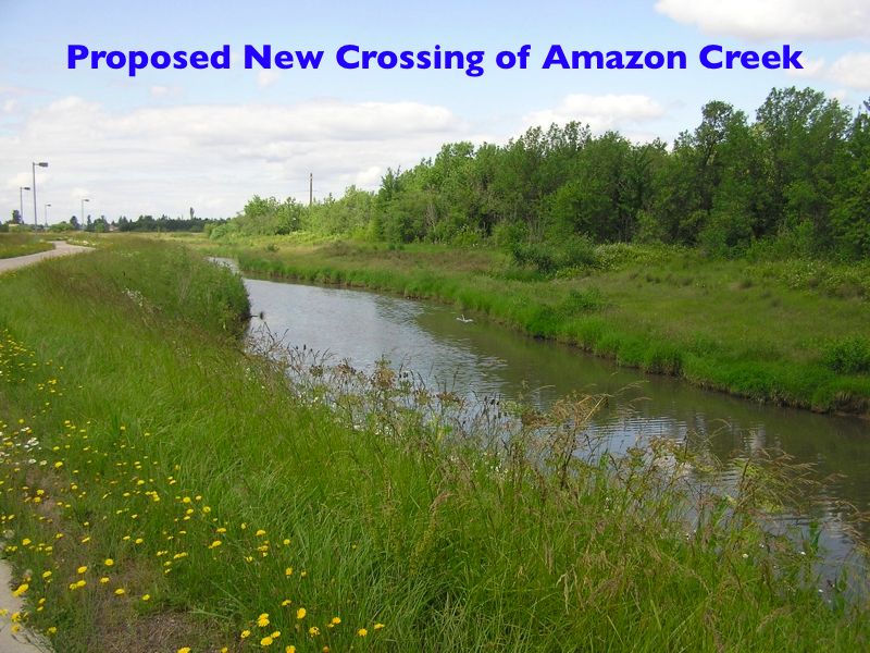
- any route for a new porkway would clearcut forest, pave wetlands, fill in part of a critical Amazon creek tributary (east of Beltline), destroy rare habitat and increase pollution
- fixing Beltline makes more sense than building a new expressway that would overload 6th and 7th Avenues, Beltline will always be the key connection between west Eugene and I-5 - relocating McKenzie Willamette (Triad) hospital to Delta Highway would be another dumb idea that would further screw up the illusion that Eugene cares about sensible land use / transportation planning. See hospital.html for a list of better locations for the new hospital.
| Alternatives Comparison | North
of tracks |
South
of tracks |
WETLANDS
alternative |
| Traffic Issues | |||
| Traffic on West 11th | |||
| Traffic on 6th and 7th | |||
| Beltline | |||
| Connect I-5 and Oregon 126 | |||
| Cost | |||
| Ecological Impacts | |||
| Amazon Creek impacts | |||
| air and water pollution | |||
| deforestation | |||
| wetland destruction | |||
| sand and gravel | |||
| Legal impacts | |||
| Land and Water Conservation Funds | |||
| Section 4(f) | |||
| Clean Water Act | |||
| NEPA - consideration of alternatives | |||
| NEPA - Cooperating Agencies | |||
| Logical Termini | |||
| Peak Oil and Year 2025 planning | |||
FHWA talking points for their new route (with rebuttals)
This memo was sent to the MPC to brief them on talking points to promote the porkway before Thursday's meeting. Note that some of them are particularly absurd, and others easily refuted.
The format for this memo is it is divided into themes, with each section starting with a potential public comment and how the government should respond to them.
Comments from WETLANDS are CAPITALIZED.
West Eugene Parkway
Public Comments / Possible Agency Response
The proposed alignment is “right through the middle” of the wetland
Investigate an alignment west of Beltline that is along the southern boundary
of the West Eugene Wetland but as much as possible, outside of the West Eugene
Wetland and off of BLM property. (this alignment is estimated to impact 27 total
wetland acres including 10 LWCF acres as compared to the 37 total and 21 LWCF
acres impacted by the current alignment)
NOTE: ANY ROUTE FOR THE WEP WOULD DECIMATE THE WEST EUGENE WETLANDS. IN CONTRAST, THE WETLANDS ALTERNATIVE WOULD HAVE MINIMAL ENVIRONMENTAL IMPACTS, AVOID THE HEART OF THE REMAINING NATURAL AREAS (ON EITHER SIDE OF BELTLINE) AND WOULD BE A MORE EFFICIENT EXPENDITURE OF SCARCE HIGHWAY FUNDS. THE WETLANDS ALTERNATIVE IS NOT A "NEW ROUTE" -- IT IS A COMBINATION OF APPROACHES TO MITIGATE TRAFFIC FLOW PROBLEMS, COORDINATE LAND USE AND TRANSPORTATION AND SHIFT PLANNING TO PREPARE FOR PEAK OIL AND CLIMATE CHANGE.
Reduce Wetland impacts
Any revised locations should impact fewer total acres of wetlands and fewer
acres of high functioning wetlands than the current preferred alignment
Stay on structure as much as possible over land currently designated as “wetland”
Contain roadway runoff
Maintain all waterways and minimize impedance to surface and groundwater flows
NOTE: THE CLEAN WATER ACT REQUIRES A WETLAND DESTRUCTION PERMIT TO ONLY BE GIVEN TO THE LEAST DAMAGING ALTERNATIVE. SINCE THE WETLANDS ALTERNATIVE IS A REFINEMENT OF THE JUNE 2001 INTERGOVERNMENTAL "WEST EUGENE CHARETTE" CONSENSUS DECISION TO SELECT "NO BUILD," AND SINCE THE WETLANDS ALTERNATIVE MEETS THE "PURPOSE AND NEED" BETTER THAN THE WEP, THE MINIMAL IMPACT OF THE WETLANDS ALTERNATIVE MEANS THAT THE ARMY CORPS OF ENGINEERS CANNOT GIVE ODOT A PERMIT TO DESTROY WETLANDS FOR THE WEP.
Reduce visual impacts
Cross railroad near current crossing
Investigate an “at grade” intersection with Terry Street.
Plant native vegetation / trees to act as a screen between the roadway and the
wetlands
Investigate use of earth berms and or walls adjacent to WEP at strategic locations…these
berms and walls should be screened with native vegetation
NOTE: NONE OF THESE AFTERTHOUGHTS WOULD CHANGE THE FACT THAT THE WEP WOULD BECOME THE "DOMINANT FEATURE" OF THE WEST EUGENE WETLANDS - AS THE BLM HAS ELOQUENTLY WRITTEN IN PAST REPORTS.
Reduce noise from roadway
“Jersey” shape barrier on structures to “contain” tire
noise
Use of roadside earth berms /walls and plantings where possible
Possibly relocate alignment to near southern boundary of West Eugene Wetland
property
NOTE: RHETORIC IN A REPORT DOES NOT REDUCE THE SOUND OF TRUCKS SPEEDING AT 65 MPH THROUGH NATURAL AREAS.
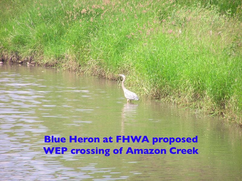
Protect the Butterfly (and all endangered / protected species)
Supplement BLM activities to produce a “recovery plan.” Will also
need to involve U S Fish & Wildlife (and others) who have already done some
work on a recovery plan. May want to hire Cheryl Swartz or other experts to
assist with the details of the plan and eventual implementation.
Work to establish a new colony (or colonies) in the West Eugene Wetland away
from the project…may need Oregon Zoo assistance in propagating lupine
and perhaps “captive breeding” of butterflies. Possible use of Eugene
schools to assist with rearing Kincaid’s Lupine (or a similar lupine)
and to build community interest.
These are “Federally designated” endangered species but they have
no state status…possibly show commitment by designating them as “Oregon”
or even “City of Eugene” endangered species.
Consider possibility of using “butterfly
crossing” speed limit signs on the WEP (maybe on 126/
West 11th also) …similar to school crossing signs…to be used when
appropriate in the month of May when the butterflies are airborne.
Consider establishing a new colony (or colonies) elsewhere on BLM land for greater
assurance of survivability
NOTE: ASKING A ZOO TO HELP THE HIGHWAY DEPARTMENT AND PROPOSING "BUTTERFLY CROSSING" SIGNS FOR A FREEWAY IS PROBABLY A NEW LOW IN ABSURDITY IN THE GLORIOUS HISTORY OF PUBLIC RELATIONS PROPAGANDA. THE FACT THAT WEP PROPONENTS ARE SERIOUSLY PROPOSING "ESTABLISHING A NEW COLONY" OF ENDANGERED SPECIES ELSEWHERE IS A TACIT ADMISSION THAT THEY PLAN TO ERADICATE EXISTING POPULATIONS. THE SMITHSONIAN INSTITUTION AND MANY OTHER ESTEEMED SCIENTIFIC EFFORTS HAVE DOCUMENTED THAT THE ASSAULTS ON THE NATURAL WORLD ARE ESSENTIALLY THE "SIXTH MASS EXTINCTION" IN EARTH'S HISTORY. AS TIM HERMACH OF THE NATIVE FOREST COUNCIL HAS QUIPPED, "WE HAVE CUT THE BABY IN HALF SO MANY TIMES WE ARE ARGUING OVER THE TOENAILS."
The proposed alignment is too expensive
Look closely at structure and embankment costs
Reevaluate the intersection with US 126? Possible use of OTIA funds for Hwy
structure over RR and tie WEP into that structure rather than including the
structure in the WEP project.
Consider redesign of Terry Street intersection
NOTE: WEP PROPONENTS IN THE GOVERNMENT HAVE CONSISTENTLY, DELIBERATELY UNDERESTIMATED
THE FULL COST OF THE WEP. FOR EXAMPLE, IN 1986, THE CITY OF EUGENE FORMALLY
REQUESTED TO ODOT THAT A GRADE SEPARATED INTERCHANGE AT BELTLINE BE CONSIDERED.
IN 1997, THE SUPPLEMENTAL DRAFT ENVIRONMENTAL IMPACT STATEMENT ADMITTED THE
WEP WOULD REQUIRE AN INTERCHANGE, BUT THIS FACT (AND THE COST OF THE INTERCHANGE)
WAS KEPT OUT OF THE PUBLIC PRONOUNCEMENTS FROM THE CITY AND ODOT UNTIL AFTER
THE 2001 ADVISORY VOTE THAT WAS SOLD TO THE PUBLIC WITH THE MANTRA "THE
MONEY IS THERE." AFTER THE VOTE, ODOT ADMITTED THE MONEY WASN'T ACTUALLY
THERE.
THE WETLANDS ALTERNATIVE EXAMINES HOW MUCH ALTERNATIVE WOULD BE FEASIBLE FOR
$17 MILLION (THE AMOUNT OF MONEY ACTUALLY APPROPRIATED FOR THE WEP), FOR $88
MILLION (THE PRICE TAG USED TO SELL THE WEP TO THE VOTERS) OR FOR $169 MILLION
(THE CURRENT OFFICIAL PRICE TAG).
SEE wetlands-cost.html (perhaps the most important consideration for the alternative).
The proposed alignment negatively impacts recreation
Added bike path / trail (possibly parallel to WEP or adjacent to RR)
Consider funding / building / or at least providing for access road to BLM education
center site. Consider transportation enhancement funding to tie Education Center
paths and bikeways into larger bike / path system
Consider Transportation Enhancement project to improve other wetland trails
/ exhibits
NOTE: IN OTHER WORDS, YES, THE HIGHWAY WOULD WRECK THE LARGEST NATURAL AREA INSIDE THE EUGENE URBAN GROWTH BOUNDARY, BUT WE WILL BUILD YOU A BIKE PATH NEXT TO THE FREEWAY SO YOU CAN ENJOY CYCLING NEXT TO SPEEDING TRUCKS. THE BIKE PATH NEXT TO BELTLINE HIGHWAY HAS SOME TRANSPORTATION VALUE, BUT IT IS STILL UGLY. A BIKE PATH NEXT TO THE WEP WOULD NOT COMPENSATE FOR DECIMATING ENDANGERED HABITATS.
The proposed alternate is not the one that does the “least environmental
damage”
Is the “ROD” alignment the least environmentally damaging alternate?
The COE must make this judgment in order to issue the project a permit…this
judgment could be based on either the alignment currently shown as “the
preferred” or another alignment that meets the purpose and need…Least
environmentally damaging has some room for interpretation …IE…takes
fewer Wetland acres, allows better screening opportunities, improves butterfly
survivability, supports more mitigation than the others…etc. This judgment
may be made considering the totality of project impacts and mitigating benefits.
NOTE: NONE OF THE GOVERNMENT AGENCIES INVOLVED DARES TO MENTION THE JUNE 2001
"NO BUILD" CONSENSUS OR THE REFINEMENTS OF THAT (NEVER IMPLEMENTED)
DECISION VIA THE WETLANDS ALTERNATIVE. EVEN MOST PRO-ENVIRONMENT POLITICIANS
WHO OPPOSE THE PORKWAY AVOID THESE FACTS. IF THE OFFICIAL REVIEW OF THE WEP
HAD TO INCLUDE THE ALTERNATIVE, THEN THE PROJECT WOULD FAIL ON THE ISSUES OF
WETLANDS IMPACTS, PARK IMPACTS -- SECTION 4(F), CRITICAL HABITAT, COST, TRAFFIC
FLOW, LAND USE COORDINATION WITH TRANSPORTATION AND OTHER ISSUES.
THE WETLANDS ALTERNATIVE HAS THE LEAST ENVIRONMENTAL IMPACT AND MEETS THE PROJECT'S
"PURPOSE AND NEED" BETTER THAN ANY OF THE VERSIONS OF THE WEP CURRENTLY
BEING CONSIDERED BY ODOT AND FHWA.
Consider the need for improved public transit
Could possibly provide appropriately located “bus bays” in the event
that the WEP is chosen as a bus route and perhaps by building a “park
& ride” lot near the west end of the project. Such a park & ride
lot could also be transit stop.
Consider improvements to the park & ride lot at the Shady Rest Fern Ridge
Reservoir parking area
The WEP will remove trucks and autos from West 11th possibly creating an opportunity
for enhanced transit on West 11th
NOTE: BUILDING A LARGE, NEW FREEWAY IS NOT THE WAY TO IMPROVE PUBLIC TRANSIT,
ESPECIALLY SINCE THE WEP WOULD FUEL MORE AUTO-CENTRIC DEVELOPMENT SUCH AS THE
HIDEOUS BIG BOX SPRAWL AT WEST 11TH AND BELTLINE -- A PROJECT THAT HIGHWAY PLANNERS
AT FHWA AND ODOT WERE SHOCKED TO SEE THE CITY ALLOW TO BE BUILT.
IF ODOT WANTS TO PROPOSE BUILDING PARKING LOTS AT THE WESTERN END OF THE WEP,
THEY NEED TO FACTOR IN THE FOOTPRINT OF THAT PARKING LOT INTO THE EIS AND THE
COST OF THE NEW BUS ROUTES TO ACCOMMODATE THE TRAFFIC. A NEW BUS ROUTE ON THE
WEP WOULD NOT GO NEAR ANY RESIDENTIAL CONCENTRATIONS AND WOULD NOT BE HELPFUL
FOR IMPROVING BUS TRANSIT TO THE WEST 11TH OR HIGHWAY 99 COMMERCIAL AREAS.
THE WEP WOULD NOT CHANGE ANY TRANSIT OPPORTUNITIES ON WEST 11TH - SINCE THE
GEOMETRY OF WEST 11TH WOULD REMAIN UNCHANGED. WEST 11TH WEST OF BAILEY HILL
WOULD STILL HAVE ROOM FOR BUS RAPID TRANSIT, WEST 11TH EAST OF SENECA WOULD
STILL REMAIN TOO NARROW FOR BRT (ALTHOUGH A POTENTIAL ROUTE THROUGH THE INDUSTRIAL
ZONE, WEAVING THROUGH THE BUILDINGS TO CONNECT TO 10TH OR 9TH MIGHT BE FEASIBLE).
IF THE REGION WANTS TO IMPROVE PUBLIC TRANSIT, BANNING ADDITIONAL BIG BOX MEGASTORES,
CONNECTING LAND USE AND TRANSPORTATION DECISIONS, STARTING PEDESTRIAN DESIGN
IMPROVEMENTS AND USING SOME WEP MONEY TO FIX WEST 11TH WOULD BE IMPORTANT STEPS
TOWARD SUCCESS.
AS GAS PRICES CONTINUE TO INCREASE, PUBLIC TRANSIT USAGE IS ALSO INCREASING
IN EUGENE AND AROUND THE COUNTRY. A SERIOUS EFFORT TO MITIGATE SOCIAL IMPACTS
OF PEAK OIL WOULD INCLUDE INVESTING IN MORE TRANSIT, WHICH WOULD SERVE THE COMMUNITY
IN THE PROJECT DESIGN YEAR OF 2025 MUCH BETTER THAN A FREEWAY FOR REAL ESTATE
SPECULATORS WHO WANT TO CONVERT FARMLAND TO SUBURBAN SUBDIVISIONS OR MORE PARKING
GARAGES TO SUBSIDIZE DEVELOPERS AND CHAIN STORES.
Mitigation package is unknown and uncertain
Time to start considering options…
Screening (both visual and noise)
Wetland replacement acres (at least 2 to 1 ratio)
Butterfly Recovery Plan
Improve trails / paths
Possible assistance for Education Center
Other??
NOTE: THERE IS NO AREA LARGE ENOUGH IN THE WEST EUGENE WETLANDS TO MITIGATE THE ECOLOGICAL IMPACTS OF THE WEP. THIS IS ONE OF THE MANY REASONS WHY IT HAS NOT BEEN BUILT.
Solution should not compromise Transportation Goals
Reduce congestion on West 11th
Facilitate through movements
Improve residential access
Minimize “user costs”
Enhance Safety
Reduce travel times
Reduce travel distances
Provide for current and future traffic volumes
Reduce “infiltration” on local streets
Reduce air pollution
Improve access to West Eugene Industrial area (Freight, customers, employees)
Support Local / Regional land use plans
Support Local / Regional Economic and Employment Plans / goals
NOTE:
THE WEP WOULD WORSEN CONGESTION ON WEST 11TH AND 6TH AND 7TH,
AVOID FIXING THE REGION'S REAL ROAD FOR THROUGH MOVEMENTS (BELTLINE),
NOT IMPROVE RESIDENTIAL ACCESS (THE WEP AVOIDS THE THREE RESIDENTIAL AREAS OF
WEST EUGENE: BETHEL, RIVER ROAD, SOUTH HILLS),
WOULD MAXIMIZE USER COSTS,
WOULD WORSEN SAFETY THROUGH INCREASED NORTH-SOUTH TRAFFIC THROUGH WEST 11TH
INTERSECTIONS,
WOULD NOT REDUCE TRAVEL TIMES OR DISTANCES FOR MOST TRIPS,
IS NOT NEEDED FOR TRAFFIC VOLUMES AFTER PEAK OIL,
WOULD OVERWHELM SEVERAL LOCAL AND ARTERIAL STREETS,
WOULD INCREASE AIR POLLUTION, WOULD REDUCE ACCESS TO THE WEST EUGENE INDUSTRIAL
AREA (THE "COUPLET" OPTION AND THE "NO LEFT TURN ALLOWED"
AT SENECA WOULD MAKE ACCESS VERY CIRCUITOUS).
THE LAND USE, ECONOMIC AND OTHER LONG TERM PLANS NEED TO SHIFT TO ACKNOWLEDGE
THE FISCAL, ECOLOGICAL AND ENERGY LIMITATIONS OF THE 21ST CENTURY AND THE REGION'S
LEADERS NEED TO REFOCUS ON HOW WE ALL CAN COOPERATE TO COPE WITH ECONOMIC DISRUPTIONS,
PEAK OIL AND CLIMATE CHANGE.
LET'S MAKE 2006 THE YEAR THE WEP IS FINALLY CANCELED.
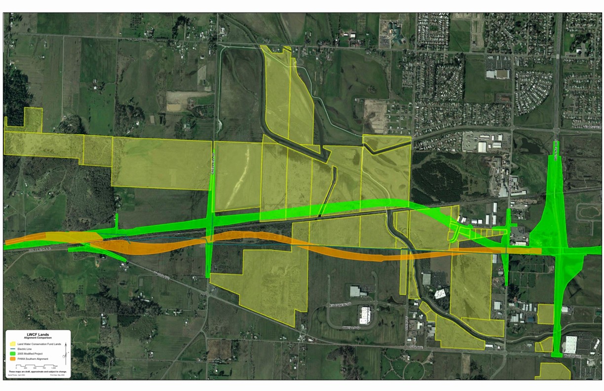
| Land and Water Conservation Fund lands (LWCF) |
yellow shows Bureau of Land Management properties purchased with LWCF money that cannot be used for the freeway
green is the color for the 2005 WEP route (the general alignment proposed since 1997)
orange is the color for the re-route of part of the WEP proposed by the Federal Highway Administration Oregon Division
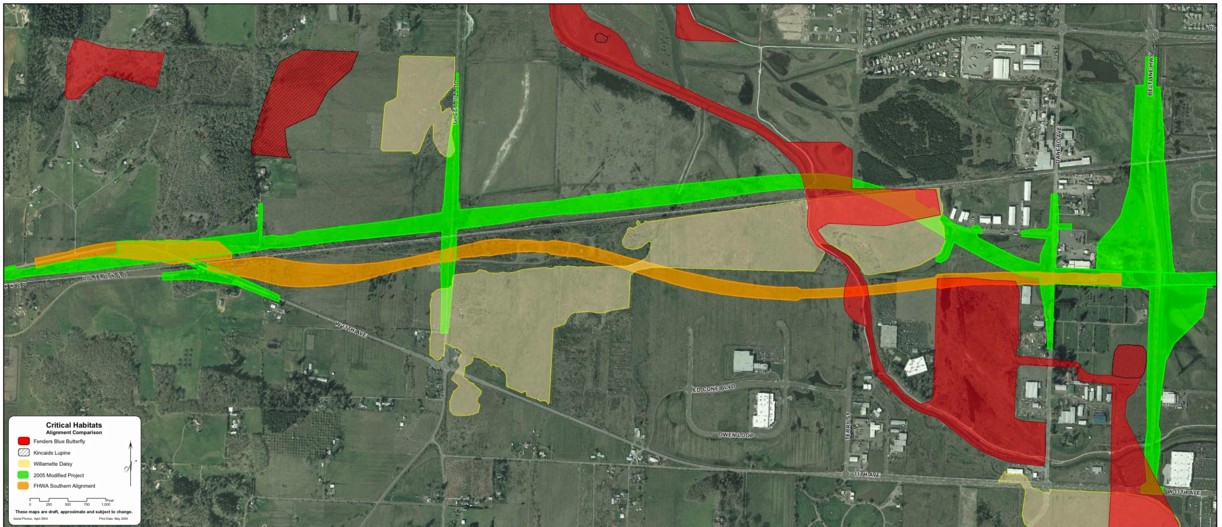
| Critical Habitats |
green is the color for the 2005 WEP route (the general alignment proposed since 1997)
orange is the color for the re-route of part of the WEP proposed by the Federal Highway Administration Oregon Division
red is the color for Critical Habitat for the Fenders Blue Butterfly
light yellow is the color for Critical Habitat for the Willamette Daisy
cross-hatches show Critical Habitat for Kincaid's Lupine
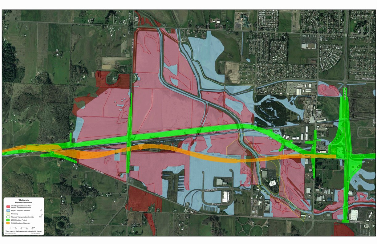
Wetlands |
red indicates wetlands identified to be protected in the West Eugene Wetlands plan
blue indicates wetlands not identified to be protected in the West Eugene Wetlands plan